The congressional conservation pipeline is clogged. This is not because it is too full of fine legislation that would elevate the conservation status of certain public lands by designating wilderness, wild and scenic rivers, and other special protection areas, but because of the general dysfunction of Congress. (I hear it was worse before the Civil War.) One bill in that pipeline, sponsored by Senator Ron Wyden (D-OR) and cosponsored by Senator Jeff Merkley (D-OR), is the proposed Oregon Wildlands Act (OWA) of 2017 (S.1548, 115th Congress).

The Molalla River in Clackamas County Oregon would receive protection as a Wild and Scenic River in a new Molalla National Recreation Area. Source: Wikipedia.
What the Act Would Do
In general, the act would designate two national recreation areas (~118,800 acres), establish one wilderness and expand another (~86,500 acres), establish ten new wild and scenic rivers and expand two others (~245.9 miles), and ban mining and damming of some tributaries of the Rogue River (~19.7 miles). In total, the act would elevate the conservation status of ~300,000 acres.
Specifically, the Oregon Wildlands Act of 2017 would do the following:
• Establish the Rogue Canyon National Recreation Area (~94,700 acres) and the Molalla National Recreation Area (~24,100 acres).
• Establish the Devils Staircase Wilderness (~30,400 acres) and expand the Wild Rogue Wilderness (56,100 acres).
• Establish the Molalla Wild and Scenic River (WSR) (21.3 miles), the Nestucca WSR (~15.5 miles), the Walker Creek WSR (~2.0 miles), the North Fork Silver Creek WSR (~6.0 miles), the Jenny Creek WSR (~17.6 miles), the Spring Creek WSR (~1.1 miles), the Lobster Creek WSR (~5.0 miles), the Elk Creek WSR (7.3 miles), the Franklin Creek WSR (4.5 miles), and the Wasson Creek WSR (10.5 miles).
• Expand the Rogue WSR (~121.0 miles, including thirty-seven tributary streams: Kelsey, East Fork Kelsey, Whisky, East Fork Whisky, West Fork Whisky, Big Windy, East Fork Big Windy, Little Windy, Howard, Mule, Anna, Missouri, Jenny, Rum, East Fork Rum, Wildcat, Montgomery, Hewitt, Bunker, Dulog, Quail, Meadow, Russian, Alder, Booze, Bronco, Copsey, Corral, Ditch, Francis, Bailey, Shady, Slide, Quartz, North Fork Galice and Galice creeks, and Long Gulch).
• Expand the Elk WSR (~52. miles, including twelve tributary streams: Blackberry, Panther, Bald Mountain, South Bald Mountain, Rock, Platinum, West Fork Panther, East Fork Panther, Lost, Milbury, McCurdy, and Bear creeks).
• Prevent the mining or damming of 19.7 miles of Rogue River tributaries (portions of Kelsey Creek, Grave Creek, Centennial Gulch, and Quail Creek).
• Prevent mining in the Chetco WSR and elevate the classification of certain segments.
How the Bill Stacks Up
Size isn’t everything, but it does matter. The single largest Oregon wilderness bill to be enacted into law thus far was the Oregon Wilderness Act of 1984, which inducted 856,956 acres into the National Wilderness Preservation System. The single largest Oregon wild and scenic rivers bill was the Omnibus Oregon Wild and Scenic Rivers Act of 1988, which inducted 1,447.4 miles of free-flowing and outstandingly remarkable streams into the National Wild and Scenic Rivers System.
The proposed OWA generally applies only to Bureau of Land Management (BLM) holdings in western Oregon, although it does include some Forest Service land on the Siuslaw and Rogue River–Siskiyou national forests. Hundreds of thousands of acres of western Oregon BLM holdings deserve an elevated conservation status. In other legislation introduced in a previous Congress by Senators Wyden and Merkley, ~279,288 acres of other important western Oregon BLM holdings would receive various kinds of congressional conservation protection:
• Illinois Valley Salmon and Botanical Area (15,000 acres)
• Kilchis Wild Salmon Refuge Area (9,000 acres)
• Smith River Salmon Restoration Unit (~2,000 acres)
• Special Environmental Zone (95,767 acres; includes all proposed and current Areas of Critical Environmental Concern, including Research Natural Areas, or RNAs)
• Grizzly Peak Primitive Backcountry Area (2,100 acres)
• Dakubetede Primitive Backcountry Area (21,200 acres)
• Wellington Wildlands Primitive Backcountry Area (5,700 acres)
• Mungers Butte Primitive Backcountry Area (10,200 acres)
• Brummit Fir Primitive Backcountry Area (2,000 acres)
• Crabtree Valley Primitive Backcountry Area (2,100 acres)
• Applegate Primitive Backcountry Area (9,000 acres)
• Cathedral Hills Natural and Recreation Area (560 acres)
• Pacific Crest Trail Protective Corridor (~33 miles, ~10,560 acres)
Some of these proposed conservation areas are imminently threatened with BLM timber sales and roading. Several of these proposed conservation designations could be tweaked in important ways to further and better cement their conservation status for this and future generations:
• Add the word “National” before “Salmon and Botanical Area” for the proposed Illinois Valley Salmon and Botanical Area.
• Expand the protective zone of the proposed Pacific Crest Trail Protective Corridor to one full mile to comport with Forest Service standards and recommendations of the Pacific Crest Trail Association.
• Elevate the conservation status of the proposed primitive backcountry areas (PBAs) to full wilderness.
• Extend the proposed Lobster Creek Wild and Scenic River by ~4 miles.
• Expand the proposed Wellington Wildlands PBA (better Wilderness) to include all eligible land.
• Establish a 3,078-acre Greens Springs Mountain Wilderness in the Cascade-Siskiyou National Monument.
• Expand the Cascade-Siskiyou National Monument to fully encompass all lands recommended by a panel of distinguished scientists.
• Extend a congressional ban on mining to all BLM-administered scenic- and recreational-classified wild and scenic rivers in western Oregon (Quartzville Creek, Salmon River, Sandy River, and Rogue River).
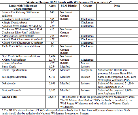
• Add all lands with wilderness characteristics (LWCs) as determined by the BLM to the National Wilderness Preservation System (see the following table).
As Oregon’s wildlands are not generally confined just to western Oregon BLM lands, so neither should this bill be. Wyden (and Merkley) should add provisions to elevate the conservation status of eastern Oregon BLM, National Forest System, National Park System, and National Wildlife Refuge System lands in the state. But that is a whole other list and therefore a whole other Public Lands Blog post.

Within the proposed Rogue Canyon National Recreation Area would be an expansion of the Wild Rogue Wilderness to include more Bureau of Land Management holdings. The Rogue River from its confluence with the Applegate River (very lower right corner of map) to the confluence of Lobster Creek (way off the map to the West) was designated as one of the nation's first wild and scenic rivers in 1968. Not shown on the map are the multiple tributary streams to the mainstem Rogue that would be added to the Rogue Wild and Scenic River by the proposed Oregon Wildlands Act of 2017. Source: Bureau of Land Management at the request of Senator Ron Wyden.